What is Red River Scramble?
Red River Scramble is a free admission, grassroots, choose-your-own-adventure motorcycle rally. While riding off-road is encouraged, the intent is to bring together like-minded adventure enthusiasts in one of the best riding locations in Appalachia, be it paved or dirt. Participants are responsible for their own food, lodging, and expenses. Registration can be found HERE.
Where can I stay in Red River Gorge?
The host(s) will be staying at the Lago Linda Hideaway in Beattyville, Kentucky. Lago Linda has several tiers of lodging available, from cabins to RV hookups and tent camping. Alternate accommodations can also be found at other nearby locations:
Where should I ride?
Attendees get exclusive access to skill-level-curated routes along the Daniel Boone Backcountry Byway (DBBB). Road-fairing riders won’t want to miss at least one loop around KY-715 and KY-77 to Sky Bridge and the Nada Tunnel, but the best riding is south of the Gorge. Hardcore Dual Sport riders will be sure to check out the The Holler, S-Tree Campground OHV, and White Sulfur OHV Trail. For all first-timers, I recommend stopping to see Chimney Top Rock while you’re out on a ride. I’ve covered more of the routes in detail here.
It is also important that attendees understand that the Red River Gorge area is littered with challenging roadways, especially for the unsuspecting; motorcyclists will encounter virtually all imaginable riding conditions in this part of Kentucky. The backroads surrounding the gorge are often less than two lanes wide, lack safety warning signs, run alongside sheer cliffs, have blind rises and curves, and are frequently occupied by wildlife and occasionally debris; your riding skills will be tested. The aforementioned roads have been traversed by all kinds of riders and all skill levels; however, I cannot emphasize enough that you must “Ride Your Own Ride“. If twisty rural backroads and majestic views sound like a good time to you, then this is an event you don’t want to miss.
Are there any maps of the area?
Conditions in this part of the country change year-to-year and season-to-season. Each year we scout both new and old roads to check difficulty levels and update the route according to the target riding skills and interest. Between that and the evolving nature of the DBBB, only online resources are available for navigation.
How do I navigate?
All riders should bring some form of navigation device while at the rally along with the basic skills necessary to use them to navigate to fuel stations, back to camp, or emergency services if needed. GPX Tracks are made available exclusively for rally attendees at registration, and are compatible with traditional GPS devices, REVER, Gaia GPS, OnX, and likely other motorcycle navigation apps.
Do I have to ride off-road?
No you don’t! If you want to come on down to the Bluegrass State to spend time with like-minded motorcycle enthusiasts, we’d love to have you. We have a number of pavement-only route available for attendees. The off-road riding and scenery is pretty incredible around this part of Appalachia, but the paved roads are also some of the best we know.
How do I know my off-road riding skill level?
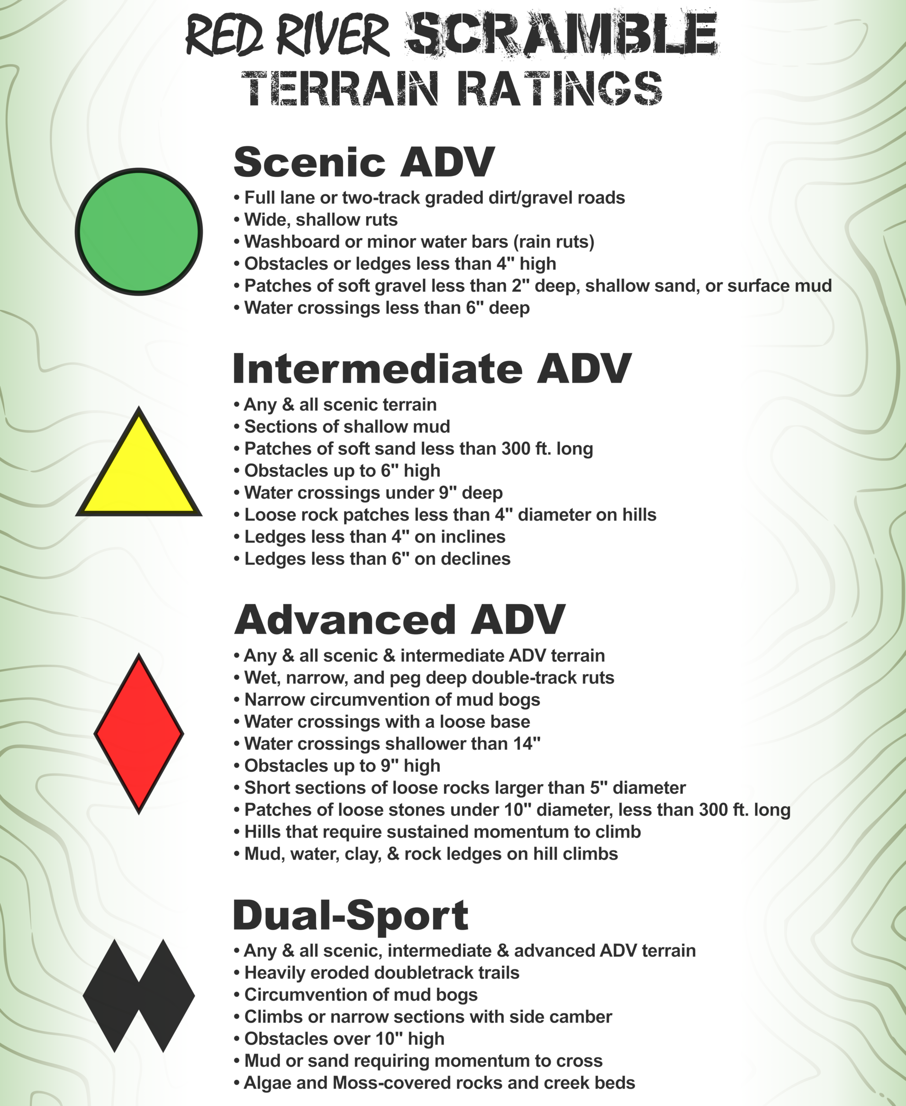
Per previous comments, “pre-planned” routes are labeled by difficulty. These difficulty levels are based on Bret Tkacs’ “Adventure” Scale, which assumes a 500-pound adventure bike, and that you’ll need to be comfortable traversing an obstacle of given difficulty on that bike. For more information, see more details on the “How To Measure Your Off-road Skills” page. For short, check out the terrain ratings image to the right (click to enlarge).
What is the Daniel Boone Backcountry Byway?
The Daniel Boone Backcountry Byway (DBBB) is an 800+ mile, OHV recreational route consisting of existing county roads. Similar to a BDR-X, the DBBB utilizes a series of primitive county roads combined with existing paved roads to form a recreation loop around the Red River Gorge and Daniel Boone National Forest area in an effort to revitalize tourism in the area. Be advised, only licensed vehicles are permitted on the DBBB; a detailed breakdown of the DBBB for adventure bikes can be found here.
Where’s a good place to eat nearby?
The Lago Linda Cafe typically serves breakfast and Dinner Friday-Saturday, so attendees generally only need leave camp for riding and gasoline. A visit to Miguel’s Pizza is an absolute must for first-time visitors to the gorge. La Cabana is also one of our local favorites, some of the best Mexican food you’ll ever have. There’s also Sky Bridge Station and Hop’s Fork for local craft beer and sandwiches. Red River Rockhouse, Red Point BBQ are other great destinations and there are a myriad of chain fast food locations in Slade, Campton, Beattyville, Stanton, and Frenchburg. There are also a few nearby grocery stores if you want to start a fire and grill out; IGA in Beattyville and Frenchburg, and Save-A-Lot in Campton and Stanton.

